Before you buy
The terrain checklist: 10 things to check before you buy land or a house
Inspections look at the house. The land it sits on gets far less attention, yet the shape of the ground decides where every storm’s water goes: away from the foundation, across the yard, or into the crawlspace.
Before you commit, find out where the lot sits (ridge, slope or low ground), where water reaches it from, and where it would sit. Then confirm the flood zone, soils, wetlands and grading, and visit during or right after rain. Most of these checks are free and take an evening.
Why the lot’s position matters
Water moves downhill along the shape of the ground. A house on a rise sheds rain in every direction. A house partway down a slope receives the water from everything above it. A house in a low spot, or at the foot of a long slope, is where that water ends up.
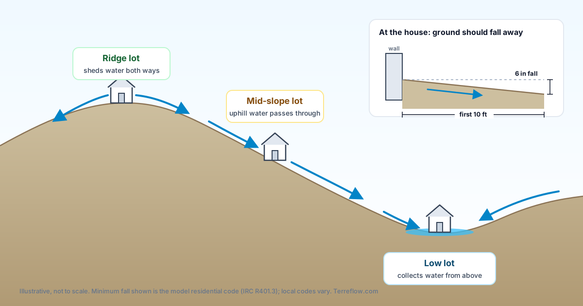
None of this makes a low lot a bad buy. It means you want to see how the water is handled: swales, drains, raised slabs, grading, and whether the neighbors’ water is directed onto the property.
The 10-point checklist
-
Where the lot sits: ridge, slope or low ground
Compare the lot’s elevation with the land within a few hundred feet. A few feet lower than the street or neighbors matters more than the absolute height above sea level.
How to check: an elevation map with contour lines, or an elevation profile drawn across the lot. In Terreflow, the Elevation tab and the vertical profile chart show both.
-
Where water reaches the lot from
Look uphill. A large area of driveways, roofs or bare slope draining toward the lot sends a lot of water past (or into) the house in a heavy storm.
How to check: a surface drainage map shows the downhill paths water takes over the terrain and how much area feeds each one. Terreflow’s Surface Drainage tab draws these paths from elevation data.
-
Low spots where water would sit
A closed depression has no downhill outlet, so water fills it until it overflows. If the house, driveway or septic field is in one, ask how it drains.
How to check: contour lines that close in a ring around a low point, or the standing-water areas on Terreflow’s drainage map. On site: puddles that last a day or more after rain.
-
Grading at the foundation
The ground right next to the house should slope away from it. The model residential code calls for a fall of at least 6 inches within the first 10 feet, or swales that carry water away where space is tight.
How to check: walk the perimeter. Soil, mulch or patios that slope toward the walls, downspouts that discharge at the foundation, and water stains or efflorescence on basement walls are warning signs.
-
How steep the land is
Steep ground costs more to build on and is harder to drain, drive and maintain. It also erodes faster once vegetation is cleared.
How to check: closely spaced contour lines mean steep ground. Ask a builder or civil engineer what the slope means for the driveway, foundation and any retaining walls.
-
The FEMA flood zone, and the base flood elevation
The flood zone decides whether a lender requires flood insurance and what it may cost. In a high-risk zone, the base flood elevation tells you how high the 1%-annual-chance flood is expected to reach.
How to check: FEMA’s Flood Map Service Center, or the FEMA layer on Terreflow’s Hazards tab. Our guide Is my house in a flood zone? explains each zone and why Zone X can still flood.
-
Soils: drainage, water table and septic suitability
Clay-rich or poorly drained soils hold water near the surface, which affects basements, yards and septic systems. Hydric soils formed under wet conditions.
How to check: the USDA Web Soil Survey reports drainage class, depth to the water table, ponding and flooding frequency, and septic absorption field limitations for a drawn area. Terreflow’s Soil tab shows clay content.
-
Wetlands on or next to the lot
Wetlands are a sign of wet ground, and building in them can require federal or state permits.
How to check: the U.S. Fish & Wildlife Service Wetlands Mapper. It is a screening map, not a legal wetland determination; for that, ask an environmental consultant or the local Army Corps of Engineers district.
-
Ditches, culverts and drainage easements
A ditch or pipe crossing the lot carries other people’s water, and an easement may limit what you can build or require access for maintenance.
How to check: the plat and title commitment, the county GIS parcel viewer, and a survey. On site, follow ditches upstream and downstream and look for culverts under the driveway or street.
-
See it in the rain
A visit during or within a day of a heavy rain shows what maps can’t: where water actually runs, where it ponds, and whether the street drains keep up.
Look for: standing water, fresh sediment fans, eroded gullies, water lines on fences or walls, a busy sump pump, and new drywall or flooring only at the bottom of walls.
Past flooding is a separate question. The checks above tell you what the land does with water. To find out whether this property has actually flooded, see how to check a property’s flood history.
When to bring in a professional
- Land surveyor: boundaries, easements and an elevation survey of the lot. An elevation certificate (used for flood insurance) is completed by a surveyor, engineer or architect.
- Civil engineer: grading and drainage design, driveway and retaining walls on slopes, and how much water reaches the lot.
- Geotechnical engineer: soil bearing, expansive clays and slope stability before you build.
- Septic designer or local health department: a soil or percolation test if the lot will need a septic system.
See the terrain around any address
Terreflow maps elevation, surface drainage, low spots, FEMA flood zones and soils for a U.S. address on one 3D map.
Analyze an address →Sources
- International Code Council, International Residential Code, Section R401.3 Drainage
- USDA Natural Resources Conservation Service, Web Soil Survey
- U.S. Fish & Wildlife Service, National Wetlands Inventory Wetlands Mapper
- FEMA, Flood Map Service Center
- U.S. Geological Survey, 3D Elevation Program (3DEP)